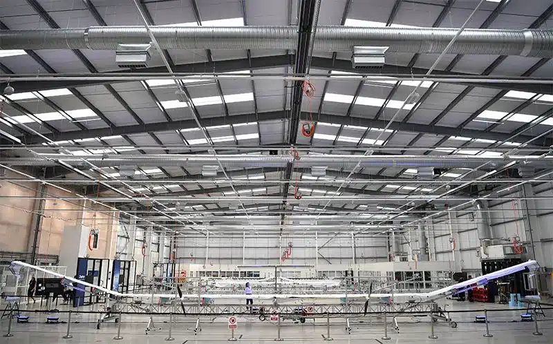
In April, if all goes to plan, a spindly uncrewed aeroplane with a wingspan wider than a jumbo jet will take flight in Puerto Rico. Powered by solar panels and soaring up to 20 kilometres high, the plane, called Odysseus, will test a new kind of high-altitude, long-duration flight — on which researchers will soon fly instruments.
“This is the most exciting thing that’s ever happened in my entire scientific lifetime,” says James Anderson, an atmospheric chemist at Harvard University in Cambridge, Massachusetts, who has worked on the concept for three decades. “It’s hard for me to go to sleep at night.”
Odysseus is one of the latest high-altitude pseudosatellites (HAPS), so named because they fly tens of kilometres above Earth, but do not make it all the way to orbit. The platforms range from solar-powered drones such as Odysseus, which was developed by Aurora Flight Sciences in Manassas, Virginia, to floating airships such as the Stratobus that Thales Alenia Space in Cannes, France, hopes to have ready for the early 2020s.
After decades of flying as one-off experimental aircraft, HAPS are poised to become part of the mainstream aerospace industry, thanks to technological advances such as better batteries and solar cells. Stratospheric aircraft could yield US$1.7 billion in revenue over the next decade, says a 2018 analysis from the Northern Sky Research consulting firm in Cambridge, Massachusetts.
For researchers, HAPS offer higher resolution than satellites can achieve, over a broader area than aeroplanes can study, and with more precision than drifting balloons can muster. They can hover over a particular region for months, with applications that include Earth observation, telecommunications and navigation1.
“Now we can really start dreaming about what we can do with these systems,” says Thorsten Fehr, an atmospheric scientist with the European Space Agency (ESA) in Noordwijk, the Netherlands. Researchers will talk about some of those dreams — including using HAPS for better air-quality monitoring and water management in urban areas — at a conference organized by ESA in Leiden, the Netherlands, this week.
Cruise control
Last year, Airbus Defence and Space flew its solar-powered Zephyr drone in the stratosphere for more than 25 days, a record. The company in Ottobrunn, Germany, is developing a version of the Zephyr that has a larger wing span — 33 metres, up from 25 — and will be able to carry heavier payloads such as scientific instruments. A Zeppelin-like airship, such as the Stratobus, could carry even more equipment. “Each technology has its niche,” says Juan Lizarraga Cubillos, who studies HAPS telecommunications applications at ESA. “It’s not either-or.”
At the Leiden meeting, researchers will talk about ways that HAPS could help science. Among them is an air-pollution-monitoring project led by the technology company GMV of Tres Cantos, Spain. It will look at how HAPS platforms could track air quality by studying emissions from Rotterdam in the Netherlands and Seville in Spain, says Amaya Atencia Yépez, a mathematician and aerospace engineer at GMV.
Satellites pass over a city once a day at most, notes Fehr. “You get a very interesting view of the chemistry which is around, but only once a day,” he says. With a HAPS hovering at 20 kilometres over a city, researchers could see how emissions wax and wane throughout the day. They could also better connect the satellite observations with those from ground-based pollution-measuring stations.
Some of the first targets for HAPS atmospheric studies will be smog-forming nitrogen dioxide (NO2) emitted by power plants and other industrial sources, says Frederik Tack, an atmospheric scientist at the Royal Belgian Institute for Space Aeronomy in Brussels. Satellites such as the European Sentinel-5 Precursor mission can monitor air pollution at a relatively coarse resolution, with pixels that are 3.5 by 7 kilometres. Aeroplane flights can gather much more precise measurements of NO2plumes, down to a resolution of around 100 metres2, but are expensive.
Putting a nitrogen-dioxide sensor on a HAPS platform would allow researchers to monitor pollution plumes at scales of about 0.5 kilometres for months, says Tack — meaning they could track emissions hotspots in a city. His team is developing NO2 sensors for a planned Belgian–German stratospheric aeroplane that could be operational by the early 2020s.
Other HAPS instruments could monitor some of the many flood-control dykes in the Netherlands, says Liduin Bos-Burgering, a meteorologist and hydrologist at Deltares, a research institute in Utrecht, the Netherlands. Her team is exploring how data gathered by HAPS could be used in flood forecasting or for emergency response during flood disasters.
For Anderson, who has flown scientific instruments on repurposed US spy planes to discover the cause of the Antarctic ozone hole, the upcoming Odysseus flight is a chance to show what HAPS can do. He is building instruments for the plane that will measure how chlorine and bromine react in the stratosphere, where they eat away at the protective ozone layer.
This year, Anderson’s team plans to use Odysseus to study how ozone is destroyed by many of the same reactions during big summer thunderstorms over the central United States. “We can lock onto the storm and follow it for days to weeks, monitoring the chemical changes,” he says. “This aircraft gives us opportunities that were never possible before.”
Nature 566, 308-309 (2019)

